Saltwater Intrusion and Drought Salinity Barriers
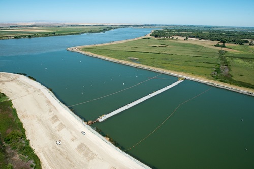
A photo of the West False River emergency drought barrier.
The Sacramento-San Joaquin Delta (Delta) is influenced by tides from the San Francisco Bay with flood tides pushing ocean water upstream. However, if saltwater were to intrude too far inland and enter the central Delta, fresh water supplies would be compromised. This would impact Delta agriculture, local municipal supplies, and the natural environment. Additionally, California’s primary water delivery system, which supplies water to 27 million Californians and supports the world’s fifth largest economy, would be threatened.
Generally, flows from the Sacramento and San Joaquin Rivers keep tidal saltwater out of the central Delta. However, during periods of extreme drought, the natural upstream flows combined with water releases from upstream reservoirs provides inadequate flows necessary to prevent salty ocean water from moving into the central Delta and through the Delta. The prevention of saltwater intrusion requires intervention and presents a tough water management challenge. Data from past installations have demonstrated that drought salinity barriers significantly minimize saltwater intrusion.
A drought salinity barrier is a physical obstacle which could be constructed in one or more strategic Delta channels to:
- Effectively prevent tidal saltwater intrusion into the Delta
- Protect water quality and prevent contamination of Delta water, including water for Delta agriculture and municipal supplies
- Reduce the amount of water released from upstream reservoirs during a drought which preserves stored water for future needs.

This map shows the location of the West False River Drought Salinity Barrier near the mouth of the West False River.
To better prepare for future drought conditions in the face of climate change, DWR has been planning and preparing environmental documents that would allow DWR to respond to drought through the installation of a drought salinity barrier in West False River. Under the current proposal, environmental permitting would allow the installation of a salinity barrier up to two times over 10 years, from 2026-2035. It would be an approximately 800-foot-long by approximately 150-foot-wide (2.75-acre) trapezoid shaped rock structure set perpendicular to the channel with a submerged base tapering to an approximately 12-foot-wide crown which would be set above the water level.
The West False River location is well suited to help prevent saltwater from entering Franks Tract, a flooded former agricultural island connected to several channels, predominantly from the San Joaquin River and West False River (see Figure 1 for the project’s proposed location). Franks Tract has significant water quality effects in the Central Delta, particularly in dry years when salinity could intrude because of a lack of freshwater flows. Thus, a barrier at West False River would protect existing water quality by shifting the main pathway for tidal flow into the San Joaquin River and into Old River northeast of Franks Tract, where flow tends to be lower in salinity than in either False River or Franks Tract. The barrier would be in the identical location as the 2021-2022 Emergency West False River Drought Salinity Barrier (discussed in the following section).
In November 2024, DWR released a Final Environmental Impact Report (FEIR) analyzing potential effects of future drought salinity barrier installations on the West False River in the Sacramento-San Joaquin Delta. The FEIR looks at the environmental impacts of installing a drought salinity barrier if needed across West False River in the Delta twice within a 10-year timeframe. The barrier, which would remain in place for up to 20 months, would help reduce saltwater intrusion into the central Delta, providing the State with greater flexibility to respond to future droughts, which are growing more frequent and extreme due to climate change. It is anticipated that the necessary environmental permits for the project would be issued advance of the potential need for a future installation.
- NOP Environmental Impact Report for West False River Drought Salinity Barrier Project
- West False River Drought Salinity Barrier Project CEQA EIR Public Meeting Presentation July 27, 2022
- West False River Drought Salinity Barrier Project CEQA EIR Public Scoping Meeting Presentation March 9, 2022
- West False River Drought Salinity Barrier Project Draft Environmental Impact Report July 2022
- West False River Drought Salinity Barrier Project Final Environmental Impact Report (Released November 2024)
Emergency West False River Drought Salinity Barrier
In response to worsening drought conditions in California, and consistent with the Governor’s Emergency Proclamations (EP) 4-21-21, and EP 5-10-21, DWR constructed a temporary Emergency Drought Salinity Barrier in June 2021 across the West False River in the Sacramento-San Joaquin Delta. The barrier remained in place until it was removed in November 2022. While in place, the barrier helped to prevent incoming salty tides from intruding into the central Delta, which proved important for purposes of water quality protection in the central Delta and preserving upstream reservoir storage.
Emergency North Delta Drought Salinity Barriers Contingency Planning
In response to Governor Newsom’s May 10th, 2021 Emergency Drought Proclamation, DWR initiated investigation and planning activities for potential North Delta Drought Salinity Barriers .
California’s three driest years of record (the drought of Water Years 2020-2022) were followed by a wet and very snowy Water Year 2023. The water year wrapped up with 141 percent of statewide average precipitation and 237 percent of April 1st Sierra-Cascades snowpack. The year’s snowpack was one of the largest on record, ending the state’s driest consecutive three-year period with one of the snowiest years of record. In response, Governor Newsom’s Executive Order N-5-23, issued in March 2023, ended the clause in the previous drought proclamations that authorized the potential need for the planning and terminated the investigation and planning activities for the North Delta Drought Salinity Barriers.